Thirty questions in three groups, from warm-up to hard, plus a map round where you name the continents and oceans. Every answer comes with a short explanation, so the answer key teaches something even when a question was missed.
The groups are about how much a child needs to already know, not about age. Starter questions need only the basics of a globe. Explorer questions need some countries and famous places. Expert questions are hard enough that plenty of adults will miss a few.
How the answers are decided
Some geography questions have more than one answer depending on who you ask. This quiz uses these conventions, and says so where it matters:
- Seven continents: Africa, Antarctica, Asia, Australia, Europe, North America and South America. This is the model most schools in the United States and the United Kingdom teach. Other countries teach five or six, for example by counting the Americas as one continent.
- Australia is the continent; Oceania is the wider region that also takes in the Pacific islands.
- Five oceans: Pacific, Atlantic, Indian, Southern and Arctic.
- "Largest" means by area unless a question says otherwise.
- No question depends on a disputed border. The one question about population (30) says which year its answer is based on.
The answers print on a separate page.
Starter
- How many continents are there?
- What is the largest ocean on Earth?
- Kenya is a country on which continent?
- Which continent is also a single country?
- The equator is an imaginary line halfway between which two points?
- Which continent is almost completely covered in ice?
- What is the capital city of France?
- Which ocean lies between the Americas and Europe and Africa?
- Brazil is a country on which continent?
- On most maps, which direction points to the top of the page?
Explorer
- The Great Pyramid of Giza is in which country?
- The ancient city of Machu Picchu is high in the mountains of which country?
- Which is the largest country in the world?
- What is the capital city of Japan?
- Which river flows through the city of Cairo?
- The Great Barrier Reef lies off the coast of which country?
- Mount Everest is on the border between Nepal and which other country?
- Which European country is shaped like a boot?
- What is the capital city of Canada?
- Madagascar is a large island in which ocean?
Expert
- Which is the smallest country in the world?
- What is the largest hot desert in the world?
- What is the name of the line of longitude at 0 degrees?
- Lake Baikal, the deepest lake in the world, is in which country?
- The city of Istanbul is on two continents. Which two?
- What is the capital city of Australia?
- The Andes mountains run down which side of South America, east or west?
- Which sea lies between southern Europe and northern Africa?
- The ancient city of Petra, carved into rose-colored rock, is in which country?
- Which country has more people than any other?
Map round
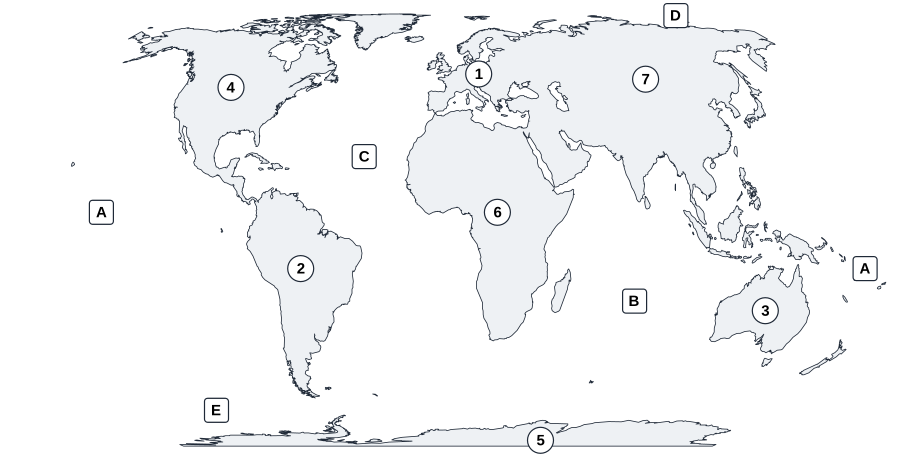
Write the name of each continent (1 to 7) and each ocean (A to E). The Pacific Ocean appears at both edges of the map, so it has the letter A twice.
Answers
Starter
- Seven. Using the seven-continent model explained above.
- The Pacific Ocean. It covers more of the Earth than all the land put together.
- Africa. Kenya is in East Africa, on the Indian Ocean coast.
- Australia. It is the only continent that is one country.
- The North Pole and the South Pole. Everything north of the equator is the Northern Hemisphere, everything south is the Southern Hemisphere.
- Antarctica. Almost all of it lies under a sheet of ice.
- Paris.
- The Atlantic Ocean.
- South America. Brazil is the largest country on that continent.
- North. That is a convention map-makers agreed on, not a law of nature.
Explorer
- Egypt. It stands at Giza, on the edge of Cairo, and is the oldest of the Seven Wonders of the Ancient World.
- Peru. Machu Picchu was built by the Inca in the Andes mountains.
- Russia. It stretches across both Europe and Asia.
- Tokyo.
- The Nile.
- Australia. The reef lies off the coast of Queensland, in the north-east.
- China. The border between Nepal and China runs across the summit, so the top of Everest is in both countries.
- Italy.
- Ottawa. Not Toronto, which is Canada's largest city.
- The Indian Ocean. It lies off the south-east coast of Africa.
Expert
- Vatican City. It is completely surrounded by the city of Rome.
- The Sahara, in North Africa. The word "hot" matters: if cold deserts count too, Antarctica is the largest desert of all, because a desert is defined by how little rain or snow falls, not by heat.
- The Prime Meridian. It runs through Greenwich in London.
- Russia. Lake Baikal is in Siberia.
- Europe and Asia. The Bosphorus strait runs through the middle of the city.
- Canberra. Not Sydney, which is Australia's largest city.
- West. The Andes run along the Pacific side of the continent.
- The Mediterranean Sea.
- Jordan.
- India. United Nations estimates show India passing China in 2023.
Map round
Continents
- 1 = Europe
- 2 = South America
- 3 = Australia
- 4 = North America
- 5 = Antarctica
- 6 = Africa
- 7 = Asia
Oceans
- A = Pacific Ocean
- B = Indian Ocean
- C = Atlantic Ocean
- D = Arctic Ocean
- E = Southern Ocean
Keep going
If your child enjoys flags, the flag matching worksheet is next, and the 50 states map quiz does the same job for the United States. For choosing a first geography book, and what changes between ages four and twelve, read how to choose geography books for kids.
Our geography books go deeper than a quiz can. Flags of the World covers all 193 countries with a flag, capital, map and quick stats for each, color-coded by continent. The 20 Regions of Italy and 50 Must-See Attractions in Israel each take one country in depth. All four are compared on the geography books for kids page.