This free geography puzzle pack is a 12-page printable PDF for students ages 8 to 14, about Grades 4 to 8. It has nine activities on continents, oceans, countries, capitals, landmarks, flags, physical features and map reading, plus a two-page answer key. MindGrid Books made it for parents, homeschool families and teachers, and it is free to print.
Quick facts about the pack
| Resource | World Geography Puzzle Pack: Countries, Continents, Maps & Landmarks |
|---|---|
| Made by | MindGrid Books, a publisher of geography and puzzle books for children |
| Recommended ages | 8–14 |
| Approximate grades | 4–8 |
| Format | Printable PDF, 12 pages, US Letter, black and white |
| Topic | World geography |
| Use cases | Classroom, homeschool and independent learning |
| Cost | Free, with no email required |
| Answer key | Included: the last two pages |
| Time needed | About 5–10 minutes per activity; 30–45 minutes for a lesson built from several |
| Materials | A printer, pencils, and optionally an atlas or globe |
What students practise
The pack practises the core skills of world geography: knowing where continents, countries and landmarks are, and reading a map to find out more. World geography is the study of the whole Earth: its continents and oceans, its countries and cities, and its natural features. Each skill below is practised in at least one activity, and most come up in several.
Continents and oceans
Naming the seven continents and five oceans and placing them on a blank world map. The pack uses the seven-continent model most US schools teach.
Countries and capitals
Matching countries to their continents and capital cities, and learning that a capital is not always a country's biggest city.
Map recognition
Finding ten countries from numbered dots on an outline map, which trains the eye to recognise shapes and positions.
Physical geography
Physical geography is the part of geography about natural features: mountains, rivers, deserts and oceans. Students place well-known ones on their continents.
Landmarks
Linking ten famous places, from the Eiffel Tower to Machu Picchu, to their countries, and sorting landmarks into natural and built.
Geographic reasoning
Working out an answer from clues: riddles, hemispheres, seasons and which way a journey runs, rather than recalling a fact.
Basic map skills
Map skills are the tools for reading a map: a grid for finding places, a compass for direction and a scale for distance. An invented island lets students practise all three.
The nine activities in the pack
The PDF has one introduction page, nine one-page activities and a two-page answer key. Every activity prints on its own page, so you can hand out a single sheet or the whole set.
- 1. Continents and Oceans. Write the name of each numbered continent and lettered ocean on a world map, with a word bank and two quick questions.
- 2. World Map Challenge. Ten numbered countries on an outline map to name, then three reasoning questions about them.
- 3. Match Countries to Continents. Twelve countries to sort into six continents.
- 4. Countries and Capitals. Twelve countries matched to their capitals, plus a circle-the-capital round for three countries whose biggest city is not the capital.
- 5. Famous World Landmarks. Ten landmarks matched to their countries, and six more sorted into natural or built by people.
- 6. Flags and Countries. Eight flags described in words, to name the country, and two to sketch from memory.
- 7. Mountains, Rivers and Oceans. Ten physical features placed on their continents, and four fill-in-the-blank facts.
- 8. Geography Riddles and Reasoning. Six “who am I?” riddles and four short reasoning problems.
- 9. Map Reading: The Island. Six questions on an invented island that has a grid, compass rose and scale bar.
The last two pages are the answer key for all nine. The riddles and reasoning questions have short explanations, not just the answer.
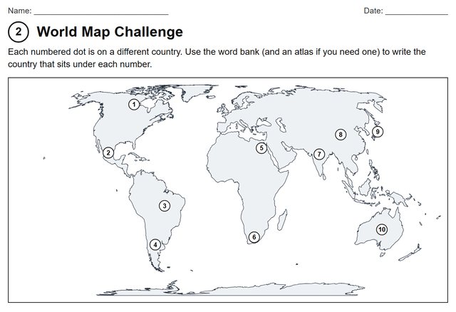
Activity 2: name ten numbered countries on an outline map.
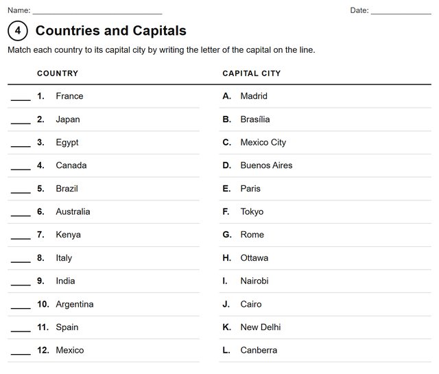
Activity 4: match countries to capitals.
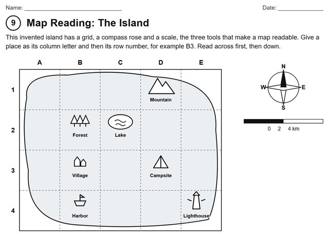
Activity 9: read a grid, compass and scale.
How to use the geography worksheets
The activities work alone, in pairs or in small groups, and each one stands on its own page. That makes the pack easy to fit around whatever else you are teaching.
- Individual work. Hand a student a page and an atlas. The word banks mean nobody is stuck on a blank line.
- Pairs. On the two map pages one student finds a place while the other checks it against the key or an atlas, then they swap.
- Small groups. Give each group a different page, then have the groups present one surprising answer each.
- Homeschool. Spread the nine pages over a week, one a day, or use a page as the starting point for a deeper look at one continent.
- Warm-up. The riddles page or the continent-and-ocean map takes about five minutes at the start of a lesson.
- Geography review. Use the matching pages as a quick check before a unit test, then compare answers with the key.
- Enrichment. Students who finish early can do the “challenge” question on page 3, or invent their own island map with a grid for a classmate to read.
Mini lesson plan: world geography in 30 to 45 minutes
This lesson uses three pages from the pack for one class period. It is a suggestion, not a requirement, and it is not tied to any particular curriculum or standards document.
| Grade level | Grades 4–8 |
|---|---|
| Suggested duration | 30–45 minutes |
| Format | Individual, pairs or small groups |
| Topic | World geography |
| Materials | Printable worksheets, pencils, and an optional atlas or map |
Learning objectives
- Identify the major continents and oceans.
- Associate selected countries with their geographic regions.
- Recognise notable landmarks and physical features.
- Practise map reading and geographic reasoning.
Suggested sequence
- Warm-up (5 minutes). Activity 1, Continents and Oceans, done individually.
- Main task (15–20 minutes). Activity 2, World Map Challenge, in pairs, with an atlas for checking.
- Extend (10–15 minutes). Activity 9, Map Reading, or Activity 8, Riddles and Reasoning.
- Review (5 minutes). Go through the answer key together. Ask which answer was hardest and why.
More free geography resources
This pack is worksheet-style: students fill in maps, matching tables and riddles. If you want something different, these free pages cover related ground:
- Geography quiz for kids — 30 questions in three levels with explained answers, better for a game or a quick check than a worksheet.
- Flag matching worksheet — twelve world flags to match, plus five look-alike pairs.
- Geography puzzles for kids — five brain teasers to read on screen, with hints and answers.
- How to teach kids world flags — a guide to the eight flag families.
- All free printables — chess puzzles and a 50 states map quiz as well.
Questions about the free geography pack
What age is this geography worksheet pack for?
Ages 8 to 14, roughly Grades 4 to 8. Younger children can do the matching and map pages with an adult; older students will find the riddles, reasoning questions and island map more of a challenge.
Is the geography printable free?
Yes. The PDF is free to download and print, and no email address or signup is needed.
Can teachers use these worksheets in the classroom?
Yes. The pack is free for personal, homeschool and classroom use, including photocopying for your own students. It is not for resale or redistribution as a standalone commercial product.
Can homeschool families use it?
Yes. Each activity is a single page, so families can do one a day, repeat a page later for review, or follow up a page with a library book or atlas.
Are answer keys included?
Yes. The last two pages of the PDF are a complete answer key for all nine activities. Detach or keep them back until students have finished.
What geography topics are included?
Continents and oceans, countries and capitals, a world map challenge, landmarks, flags, physical features such as mountains and rivers, riddles and reasoning, and basic map reading with a grid, compass and scale.
Does the pack cover continents and oceans?
Yes. The first activity has students label all seven continents and five oceans on a world map, and the countries on later pages are sorted by continent.
Do students need an atlas or map?
No. Every page can be completed without one, and the word banks supply the names. An atlas or globe is useful for checking answers and for the extension questions.
Is it printer-friendly?
Yes. The pages are black and white on US Letter paper, with no tinted backgrounds and only a pale grey on the two maps.
Using and sharing the pack
Free for personal, homeschool, and classroom use. Not for resale or redistribution as a standalone commercial product. You are welcome to print as many copies as you need for your own children or students. Please link to this page rather than re-hosting the PDF, so everyone gets the current version.
The world map is drawn from Natural Earth, which is in the public domain. Every activity was written for this website; none is a page from one of our books.
If your students enjoy puzzles
The Great Geography Puzzle Expedition is our paperback of 100 original geography puzzles for ages 8 to 12, set in real places around the world, with a hint and an explained answer for each. See all MindGrid geography books for kids to compare it with our atlases.