This quiz is a blank outline map of the United States with every state numbered from 1 to 50. The job is to write the right state name next to each number. It works as a first test, as a weekly check, or as a race against your own last score.
The numbers run in rough rows from north to south and west to east, not in alphabetical order, so they do not give the answers away. The eight smallest states in the Northeast have their numbers in a column off the Atlantic coast, with a line pointing to each one.
How to use it
- All at once. Print the map and the answer lines, and fill in as many as you can in one sitting. The gaps show what to learn next.
- One region at a time. Pick a corner of the map — the Northeast, the West Coast, the states along the Mississippi — and only do those numbers this week.
- Timed. Once most of the map is known, time a full attempt and try to beat it next week. Accuracy first, speed second.
- In pairs. One person holds the answer key and marks; the other answers. Then swap. Being the one who marks is good practice too.
The answers print on a separate page.
The map
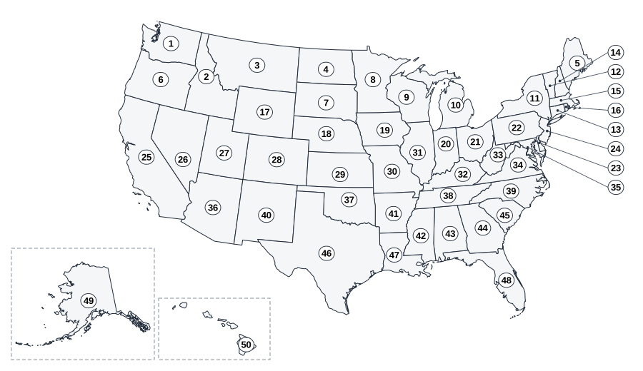
Alaska and Hawaii are drawn in the boxes at the lower left, which is how most US maps show them. They are not in their true positions — Alaska is north-west of Canada and Hawaii is far out in the Pacific — and they are not at their true sizes: Alaska is the largest state by area and is drawn much smaller than it really is here.
Answer lines
- 1
- 2
- 3
- 4
- 5
- 6
- 7
- 8
- 9
- 10
- 11
- 12
- 13
- 14
- 15
- 16
- 17
- 18
- 19
- 20
- 21
- 22
- 23
- 24
- 25
- 26
- 27
- 28
- 29
- 30
- 31
- 32
- 33
- 34
- 35
- 36
- 37
- 38
- 39
- 40
- 41
- 42
- 43
- 44
- 45
- 46
- 47
- 48
- 49
- 50
Capitals practice
Only start this once most of the map is secure: capitals are a second set of fifty names, and learning both at once is much harder than learning them one after the other. Each set has ten states and a bank of their ten capitals. Write the right capital next to each state.
Set A
- California
- Texas
- New York
- Florida
- Illinois
- Pennsylvania
- Washington
- Kentucky
- Nevada
- South Dakota
Capital bank
- Albany
- Austin
- Carson City
- Frankfort
- Harrisburg
- Olympia
- Pierre
- Sacramento
- Springfield
- Tallahassee
Set B
- Oregon
- Vermont
- Missouri
- Michigan
- Delaware
- North Dakota
- Louisiana
- Arizona
- New Jersey
- Montana
Capital bank
- Baton Rouge
- Bismarck
- Dover
- Helena
- Jefferson City
- Lansing
- Montpelier
- Phoenix
- Salem
- Trenton
Three quick games
These need no printing at all, only the map above or any US map.
- Border chain. Name a state, then a state that touches it, then one that touches that, without repeating any. Count how long the chain gets. (Alaska and Hawaii touch no other state, so they can only start or end a chain.)
- Capital or big city? Say a city, and the other player says whether it is a state capital. Many famous cities are not: New York City, Los Angeles and Chicago are all capitals of nothing. Albany, Sacramento and Springfield are the capitals of those three states.
- Shape guess. Cover the names on a map, point at one state and describe its shape — "a mitten", "a boot heel", "a panhandle". The other player names it.
Answer key
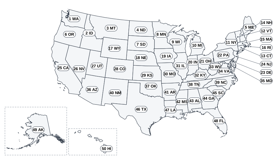
| No. | State | Code | Capital |
|---|---|---|---|
| 1 | Washington | WA | Olympia |
| 2 | Idaho | ID | Boise |
| 3 | Montana | MT | Helena |
| 4 | North Dakota | ND | Bismarck |
| 5 | Maine | ME | Augusta |
| 6 | Oregon | OR | Salem |
| 7 | South Dakota | SD | Pierre |
| 8 | Minnesota | MN | Saint Paul |
| 9 | Wisconsin | WI | Madison |
| 10 | Michigan | MI | Lansing |
| 11 | New York | NY | Albany |
| 12 | Vermont | VT | Montpelier |
| 13 | Connecticut | CT | Hartford |
| 14 | New Hampshire | NH | Concord |
| 15 | Massachusetts | MA | Boston |
| 16 | Rhode Island | RI | Providence |
| 17 | Wyoming | WY | Cheyenne |
| 18 | Nebraska | NE | Lincoln |
| 19 | Iowa | IA | Des Moines |
| 20 | Indiana | IN | Indianapolis |
| 21 | Ohio | OH | Columbus |
| 22 | Pennsylvania | PA | Harrisburg |
| 23 | Delaware | DE | Dover |
| 24 | New Jersey | NJ | Trenton |
| 25 | California | CA | Sacramento |
| 26 | Nevada | NV | Carson City |
| 27 | Utah | UT | Salt Lake City |
| 28 | Colorado | CO | Denver |
| 29 | Kansas | KS | Topeka |
| 30 | Missouri | MO | Jefferson City |
| 31 | Illinois | IL | Springfield |
| 32 | Kentucky | KY | Frankfort |
| 33 | West Virginia | WV | Charleston |
| 34 | Virginia | VA | Richmond |
| 35 | Maryland | MD | Annapolis |
| 36 | Arizona | AZ | Phoenix |
| 37 | Oklahoma | OK | Oklahoma City |
| 38 | Tennessee | TN | Nashville |
| 39 | North Carolina | NC | Raleigh |
| 40 | New Mexico | NM | Santa Fe |
| 41 | Arkansas | AR | Little Rock |
| 42 | Mississippi | MS | Jackson |
| 43 | Alabama | AL | Montgomery |
| 44 | Georgia | GA | Atlanta |
| 45 | South Carolina | SC | Columbia |
| 46 | Texas | TX | Austin |
| 47 | Louisiana | LA | Baton Rouge |
| 48 | Florida | FL | Tallahassee |
| 49 | Alaska | AK | Juneau |
| 50 | Hawaii | HI | Honolulu |
Capitals answers
Set A:
- California: Sacramento
- Texas: Austin
- New York: Albany
- Florida: Tallahassee
- Illinois: Springfield
- Pennsylvania: Harrisburg
- Washington: Olympia
- Kentucky: Frankfort
- Nevada: Carson City
- South Dakota: Pierre
Set B:
- Oregon: Salem
- Vermont: Montpelier
- Missouri: Jefferson City
- Michigan: Lansing
- Delaware: Dover
- North Dakota: Bismarck
- Louisiana: Baton Rouge
- Arizona: Phoenix
- New Jersey: Trenton
- Montana: Helena
A note on the facts here: a state capital is the city where the state government sits. All fifty names and capitals on this page were checked against the data in our atlas, and the map boundaries come from Natural Earth, a public-domain map dataset.
Keep going
For the order to learn the states in, and why capitals should come last, read teaching kids the 50 states.
The 50 States of America is our full-color atlas for this: every state gets its own page with its flag, a map, its shape, its capital, its nickname and three facts, and there is a quiz at the end of each of eight regions. For a fact and quiz book organized the same way by region, see 250 Amazing Facts About the 50 States. More activities are on the free printables page, including a world geography quiz.